

MID WiFi (Free)
Evaluation version of MID WiFi and Marine Instrument Display.
Marine Instrument Display WiFi allows you to create/follow/transfer routes, track your path, control autopilot, receive/store/forward NMEA0183 data over WiFi and see AIS targets on the map. Send/receive data through iCloud (e.g. remote anchor alarm).
MID WiFi also features the worlds first autopilot controller app for Apple Watch.
Search "Marine Instrument Display" for Lite version.
FEATURES
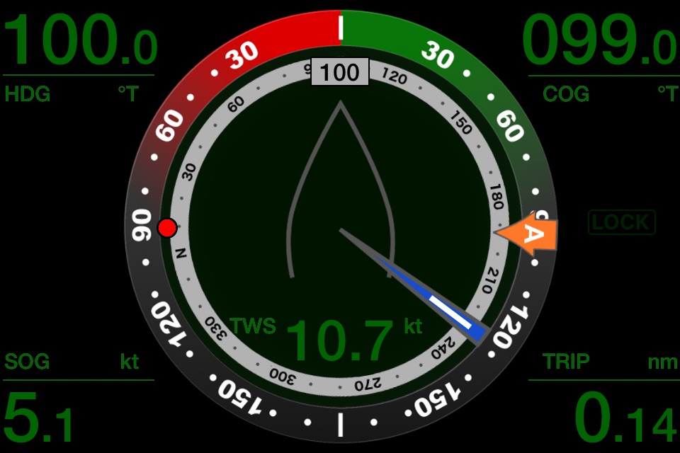
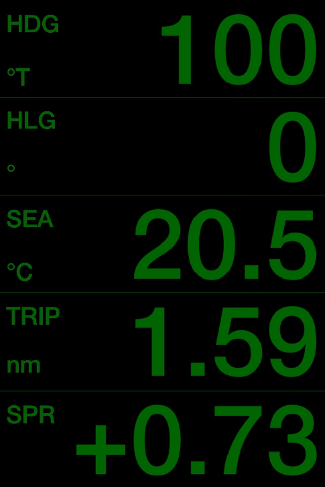
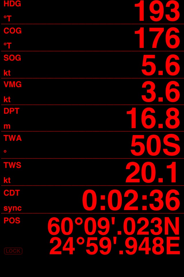
- Compass Heading (mag/true) (HDG)
- Clock (utc/local) (CLK)
* Course Over Ground (COG)
* Speed Over Ground (SOG)
* Average SOG (ASOG)
* Maximum SOG (MSOG)
* Trip Distance (TRIP)
* Trip Time (TIME)
* Countdown Timer (CDT)
* Distance to Line (DTL)
* Time to Line (TTL)
* Barometric Pressure (BPR) (NMEA or iPhone6->)
* Bearing to Waypoint (BTW)
* Distance to Waypoint (DTW)
* Time to Waypoint (TTG)
* Cross Track Error (XTE)
* Velocity Made Good to Waypoint (VMGwpt)
* Heeling (HLG)
* Position
** Apparent Wind Angle and Speed (AWA, AWS)
** True Wind Angle and Speed (TWA, TWS)
** Maximum Apparent/True Wind Speed (MAWS, MTWS)
** True Wind Direction (TWD)
** Velocity Made Good to Wind (VMGwnd)
** Boat Speed (SPD)
** Maximum Boat Speed (MSPD)
** Depth (DPT)
** Air and Sea Temperatures (AIR, SEA)
** Predicted Boat Speed (PSPD)
** Boat Speed to Predicted Boat Speed Ratio (SPR)
** Revolutions Per Minute (Engine/Shaft) (RPM)
** Propeller Pitch (PRP)
** NoLand Eng. Analog Values (EAV1-5)
** TackTick FFP1-4
** Rate of Turn (ROT)
** Fluid Levels (TANKS)
* = Internal GPS or NMEA-WiFi bridge required
** = NMEA-WiFi bridge required (e.g. Vesper Marine XB-8000 and WatchMate Vision, Simrad GoFree WIFI-1, RS232-WiFi, Digital Yacht iAIS/WLN10, ShipModul MiniPlex-2/3Wi, PilotsTech PilotPlug, iMux, Ockam LANbridge)
WIND VIEW
- Shows Apparent and True Wind Angles simultaneously
- Size of the blue sector indicates the variation in wind direction
- Red dot shows the BTW
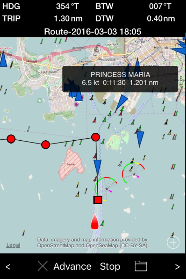
MAP VIEW
- AIS targets (**
- Create and follow routes
- Transfer routes on NMEA
- Create and replay tracks
- Autopilot control (Raymarine, requires MiniPlex-3Wi)
- Share tracks and data by email (GPX, NMEA)
- Access stored NMEA data via iTunes File Sharing
ALARMS
- Depth (Deep, Shallow)
- Anchor (Deep, Shallow, Distance)
- Wind (AWA/TWA/AWS/TWS High/Low, TWD Shift)
HOW TO USE
- Tap the SET to enter the Settings page
- Tap the value of any field to cycle through the color modes
- Tap/swipe the title of any field (such as TIME) to select the data to the field
- Tap a unit to cycle through the unit modes
- Tap the unit (°) of the heeling (HLG) to calibrate (zero angle)
- Press the value of any field at least two seconds to reset the TIME, ASOG, MSOG and TRIP
- Rename a route or a track by tapping the name of it
- Use IP address 255.255.255.255 for the UDP broadcast/multicast. The port for the Simrad GoFree discovery is 2050 or 2052, 5000-5010 are for Ockam LANbridge and 55554 for SailTimer Wind Vane.
- Use 127.0.0.1 and port 55554 SailTimer Wind Instrument
- NMEA0183 data can be forwarded as UDP multicast to other devices
- The trip time runs while moving (SOG > 0)
- The COG is shown while moving (SOG > 0)
COUNTDOWN TIMER
- Configure the start time (1 - 30 minutes) by touching the SET to enter the Settings view
- Start/sync the timer by touching the "sync"
- Stop the timer by touching the "sync" at least two seconds
- The timer beeps every minute and when 50, 40, 30, 20, 10, 5, 4, 3, 2, 1, 0 second(s) are remaining
CALIBRATION
1. The back cover must be faced forward accurately in order to get the correct compass heading.
2. Mount the iPhone/iPad securely and make sure it cannot move accidentally to ANY direction.
3. Tap the unit field (°) of the heeling (HLG). HLG is set to zero and the heading shows the correct value.
Continued use of GPS running in the background can dramatically decrease battery life.